Beware the faults
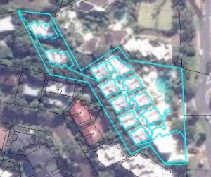
 The Digital Cadastral DataBase (DCDB) can be utilised to give you the number of units in building covered by group title. The cadastre can identify the common property, normally “Lot 0”, and each individual unit in the building, including the unit area and external shape. This is very useful when you have multiple floors in a building and the aerial photography or satellite view make it very difficult to identify the number of floors and number of units per floor in that building.
This method is not always reliable. We have found faults in the DCDB, when a group title property contains more than one building, that you need to be aware of. In locations were there are two or more buildings, we have seen instances of every unit “lot” within the property being assigned across multiple buildings. Let me give you an example to explain this.
Wrong by a factor of 10
Let us imagine there is a resort that is composed of group title units. There are 10 buildings in this resort. Each building has 8 floors, with 2 units per floor. Thus, we would expect the DCDB to contain 160 (10 x 8 x 2) spatial representations of the units at that location, together with the common property. The spatial representations of units 1-16, you would expect to be located in Building 1. The spatial representations of units 17-32, you would expect to be located in Building 2, and so on.
 Not so. We have come across properties where each building contains spatial representations of all 160 units, giving 1600 units (10 x 160) and 1600 separate records in the DCDB. Identifying the location of a specific unit in the DCDB will show it being located in every building. Should you count these 1600 records in your urban growth model, you will be out by a factor of 10 at that location. The worst example we have come across so far is the DCDB showing 1789 units located at one group title property, when there are only 112.
The other observation we have made is properties with this issue tend to be located in the same area. This is due to the planning zone supporting this type of development. If you were not aware of this issue and utilised the DCDB to provide with the number of multiple dwellings on a site, your urban growth model would greatly exaggerate the existing development in that area. This would have a significant impact the model’s projections and final results.
To overcome this issue, we group the spatial representations of the units by their unique identifier. With the cadastre we work with this is the attribute “Lotplan”. By grouping by this identifier, ensures only the unique attributes are processed within the urban growth model.
Other faults
Other issues we have found are inaccurate attributes assigned to the spatial geometry. We have discovered instances of the common propriety having a parish name that is different to the multiple units located inside that common property. These minor issues tend not to affect a model, unless you are grouping and aggregating on these attributes.
There are mechanisms to give feedback on Cadastral data accuracy. In Queensland, where we are located, you can send an email to CadastralAdminDataHelp@dnrm.qld.gov.au. All government authorities normally provide a method to give feedback on the cadastre they are responsible for.
Leave a Reply